Offline GPX Navigation
OffTrail lets you import GPX Tracks, download maps to your device and navigate without relying on continuous mobile coverage. It is a free app for iPhone and Android, built offline-first from the start rather than adding offline as an afterthought.
How offline GPX navigation works
Two different things are often confused: GPS and the internet. GPS is a receiver in your phone listening to satellites — it works anywhere under open sky and never needs a data connection. The internet is only needed to download maps. So offline GPX navigation is simple in principle: get the GPX Track onto the phone, get the map onto the phone, and from then on the phone can draw the map, place you on it and follow the Track entirely locally.
In OffTrail that means: import a GPX file (file manager, email, browser or share menu), download the offline map for the country you are riding, and go. Airplane mode, no SIM, a dead zone in the mountains — navigation keeps working.
What works offline
With a downloaded map: the map display, your live GPS position with course-up tracking, the GPX Tracks you loaded, off-track and wrong-way alerts, waypoints, and automatic ride recording. Two things do need a connection: downloading maps in the first place, and generating a new route (the route computation runs on OffTrail's servers). Once a route is on the map, following it is fully offline.
Before you lose the signal
Four things, in this order, while you still have Wi-Fi:
1. Import the GPX — from the file manager, email, browser or share menu. Platform detail: on iPhone, on Android.
2. Download the country in Maps — or the regions you'll cross, in the countries that are split — and check it says downloaded before you unplug.
3. Generate any route you want now — routing runs on a server, so a route you will need tomorrow has to be created today. Following it afterwards is entirely offline.
4. Check the permission: location granted, and on iPhone Precise Location on.
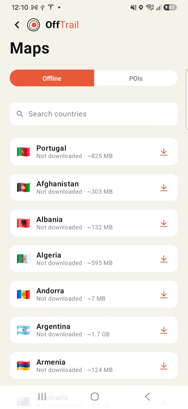
Whole-country offline maps
Offline maps are downloaded per country, as a single package — no fiddling with bounding boxes or tile counts. The largest countries are split into regions instead, so the United States comes state by state, and Canada, Germany, France, the UK, Italy and a handful of others by region. More than 100 countries are available. In countries where OffTrail has built its own map coverage — Portugal, Spain, the USA state-by-state, Australia, Russia and a growing list — the maps carry a dense off-road trail network; everywhere else a worldwide base map is used, so there is always a map under you. An optional satellite layer is available too.
GPX in, GPX out
GPX is the exchange format for Tracks, and OffTrail treats it as such: any standard GPX file can be imported, and every recorded ride is saved as a standard GPX file on your phone — share it by AirDrop on iPhone, or any share target on Android — file manager, email, chat. Nothing is locked into the app.
Where offline navigation matters most
Adventure motorcycle travel through areas with weak coverage (see motorcycle GPX navigation), 4x4 and overland trips far from towns, remote trail networks, and international riding where roaming data is expensive or unavailable. If you would rather generate a route than import one, OffTrail's Off-Road Route Generation generates routes you can then follow offline. For the full preparation checklist, read the guide to navigating a GPX without internet.
Get OffTrail free on the App Store or Google Play. Load a GPX Track, generate a route and ride.
Frequently asked questions
Does GPS work without internet?
Yes. GPS is satellite-based and independent of mobile data. Your phone knows where it is with no coverage at all — only the map needs to be downloaded in advance.
Can I navigate a GPX file in airplane mode?
Yes. With the country's offline map downloaded and the GPX Track imported, navigation, off-track alerts and ride recording all work in airplane mode.
Does the satellite layer work offline?
No. Satellite imagery streams and cannot be stored on the phone — it is online-only by design. The vector map with the off-road trail network is the one that works with no coverage, on the phone and on the car screen.
Do I need an OffTrail account?
No. OffTrail has no account for normal use.
How do I download maps?
In the app, open Maps, pick your country and download it while you have Wi-Fi or mobile data. The map is then stored on the phone and works offline.
Can I record rides offline?
Yes. Ride recording is local and automatic — it starts when you ride and saves the trip as a GPX file on your phone, coverage or not.
Can I export my recorded GPX?
Yes. Recordings are standard GPX files — share them via AirDrop, the file manager, email or any share target.